This page last revised 21 July 2007
Introduction
Ecoregion
Conservation Targets
Viability
Goals
Portfolio
TNC Action Sites
Threats
Strategies
Acknowledgements
▫
Tables
Maps & Figures
CPT Database
Appendices
Glossary
Sources
Major Habitat Types
Introduction
Major Habitat Types (MHT) are broad, typically large-scale aggregations of ecoregions of similar moisture, physiognomy, and latitude. Example MHTs include
Boundaries
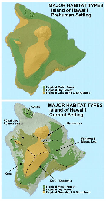
The MHT boundaries for the Hawaiian ecoregion are depicted below. The World Wildlife Federation (WWF) recognizes four ecoregions for the(continued next column)
Ecological System targets of the Hawaiian Ecoregion nest cleanly within the MHTs. For example, The Tropical Moist Forest MHT in Hawai‘i is comprised of five ecological systems: Lowland Wet, Lowland Mesic, Montane Wet, Montane Mesic, and Wet Cliffs.Similar nesting can be performed for the Tropical Dry Forest MHT andthe Tropical Grasslands, Savannas & Shrublands MHT.The integration of ecological systems into MHTs allows for ahigh degreeof accuracy reporting on their conservation status (see Global Priorites, below).
Global Priorities
The goal of The Nature Conservancy is to bring effective conservation to at least 10% of all of the Earth's Major Habitat Types by 2015. This 2015 goal is further stratified by biogeographic realms. The global context of the Hawaiian Ecoregion's three MHTs is the Oceanian Realm.
Because of its large size (relative to other Pacific island systems)and a long history of conservation efforts in the Hawaiian Islands,this ecoregion plays a significant role in realizing 2015 goals.
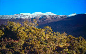
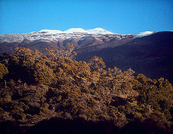
 Some of the world's wettest regions lie in the ecoregion's montane wet systems, part of the Tropical Moist Forest MHT.
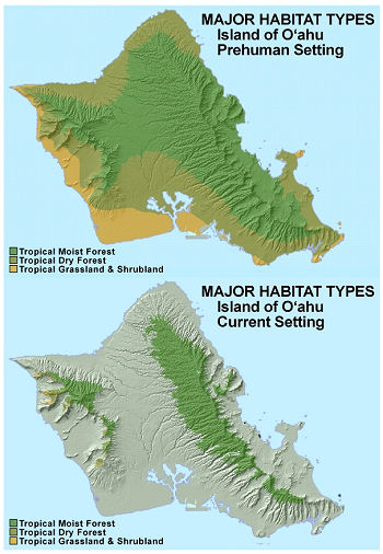
The three Major Habitat Types (MHTs) of the Hawaiian High Islands Ecoregion (right) are comprised of constituent ecological systems and represent Tropical Moist Forest (green), Tropical Dry Forest (brown) and Tropical Grassland, Savanna & Shrubland (yellow). Areas that have been coverted into non-native or anthropogenic systems are shown in grey.
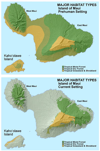
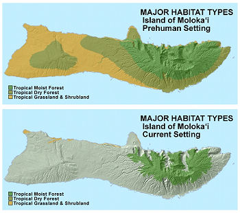
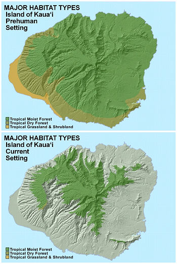
When comparing the current extent (top) of the MHTs to the prehumanextent (bottom), it is apparent that all MHTs have beensignificantly reduced in extent, particularly at lowerelevations. Tropical Dry Forest has been all but lost except onthe largest island of Hawai‘i. Similarly, nearly all of thelowland grasslands and shrublands have been lost, leaving onlysubalpine and alpine shrublands (yellow areas at the mountain tops of Maui and Hawai‘i) as the major representative of the Tropical Grassland, Savanna & Shrubland MHT.
The individual islands and their prehuman and current MHT occurrences are displayed and discussed in more detail below.
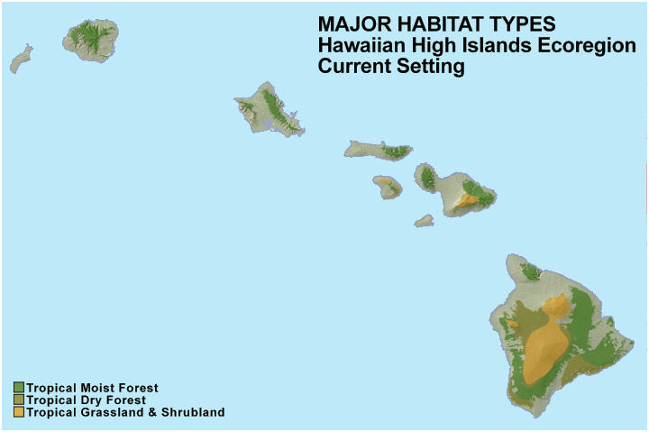
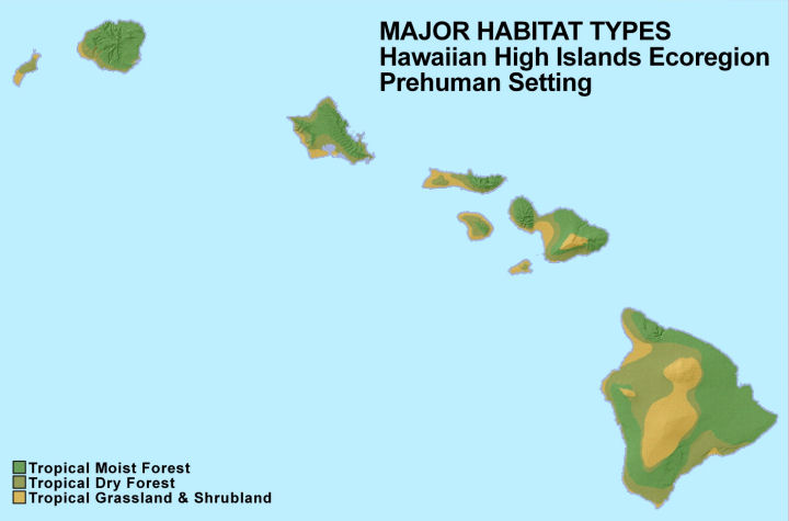
The patterns of MHT loss on the individual islands (right two columns)demonstrates clearly that disturbance and displacement of biodiversityhas been greatest in the lowlands, leaving remnant native areas athigher elevations. As a result, smaller, lower islands such asMoloka‘i, O‘ahu, and Kaua‘i, show almost completeloss of the Tropical Dry Forest and Tropical Grassland, Savanna & Shrubland MHT, but retain significant area of Tropical Moist Forest.
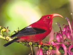
Hawai‘i includes more endangered species than any other state of the U.S.
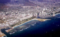
Significant portions of the lowlands have been displaced by human development.
Bringing active management to priority land- scapes isthe overall goal.
Alien species, such as feral ungulates, are a prevailing threat to native ecosystemsin Hawai‘i
The summary statistics for each of the three MHTs in the Hawaiianecoregion shows that about half of the native Tropical MoistForest has been lost, and that only a third of the Tropical DryForest area remains. The summary statistic for Tropical Grassland andShrubland is misleading in a way, because nearly all of the lowland drygrasslands and shrublands have been lost, but the vast majority of thehigh elevation grasslands and shrublands remain. Similarly, it is easyto see that for all but the two largest islands (Maui andHawai‘i), Tropical Dry Forest and Tropical Grassland andShrubland has been largely destroyed.
Tropical Moist Forest
area before humans: 795,867 hectares (1,966,629 acres)
current area: 408,790 hectares (1,010,142 acres) 49% lost
Tropical Dry Forest
area before humans: 507,520 hectares (1,254,110 acres)
current area: 172,653 hectares (426,634 acres) 66% lost
Tropical Grassland & Shrubland
area before humans: 363,299 hectares (897,731 acres)
current area: 212,933 hectares (526,170 acres) 41% lost